[an error occurred while processing this directive]
引用本文
阮浩波, 王乃昂, 牛震敏, 贾鹏.
毛乌素沙地汉代古城遗址空间格局及驱动力分析[J].
地理学报
,
2016,
71
(5):
873-
882.
[RUAN Haobo, WANG Nai'ang, NIU Zhenmin, JIA Peng.
Spatial pattern of ancient city sites and its driving forces in Mu Us Sandy Land during Han Dynasty[J]. Acta Geographica Sinica
,
2016,
71
(5):
873-
882.
]
Spatial pattern of ancient city sites and its driving forces in Mu Us Sandy Land during Han Dynasty
RUAN Haobo,, WANG Nai'ang,, NIU Zhenmin, JIA Peng
College of Earth and Environmental Sciences, Research Center for Arid Area and Desert, Lanzhou University, Lanzhou 730000, China
Fund:
Key Project of National Natural Science Foundation of China, No.41530745, No.41371114;
Abstract
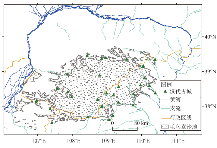
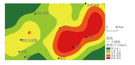
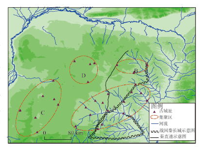
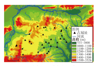
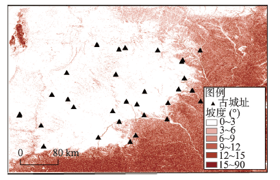
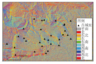
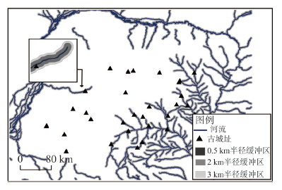
This paper presents an analysis of the spatial distribution of 31 city sites of Han Dynasty in the Mu Us Sandy Land based on Nearest Neighbor Index (NNI) analysis, space analysis and coupling analysis. It further explores the relationships between the spatial pattern of the sites and geographical factors. Point pattern analysis of 31 city sites indicates that, the average nearest neighbor distance of city sites is 25.5 km, which belongs to causal distributional pattern with the 4 causal distribution regions: the strong influence area of the Great Wall of the Qin Dynasty - the Straight Road of the Qin Dynasty (A), the weak influence area of the Great Wall of the Qin Dynasty - the Straight Road of the Qin Dynasty (B), southwestern cluster district (C) and northwestern cluster district (D) and the strong influence area of the Great Wall of the Qin Dynasty - the Straight Road of the Qin Dynasty (A) is the most important region with a proportion of 48.39% of the total. The city sites of the Han Dynasty in the Mu Us Sandy Land Desert are sparsely distributed in the west and densely in the east, which may be characterized as "patial agglomeration". The paper includes a discussion of factors influencing the spatial pattern of city sites, notably, human factors and natural factors. Although climate condition, landforms and water resources mainly restrict the selection of the city, human-driven forces, including political, military, and transport conditions, have played a leading role in the formation of the location and the number of the city sites.
Keyword:
Mu Us Desert;
ancient city sites;
Han Dynasty;
spatial pattern;
driving forces;
XiaHuijun.Study on the spatial distribution Characteristic of the historieal and cultural sites based on GIS: Case study about Yulin City [D]. Xi'an: Xi'an University of Architecture andTechnology, 2010.
WangNai'ang, HuangYingzhou, HeTonghui, et al. The environmental significance of tamping sandy layer in ancient city ramparts on Erdos Plateau.Acta Geographica Sinica, 2006, 61(9): 937-945.
WangNai'ang, HeTonghui, HuangYinzhou, et al. Discovery of Liuhu State Relic and its significance of environmental indication.Journal of Chinese Historical Geography, 2006, 21(3): 36-46.
WangNai'ang, HeTonghui, Huang Yinzhou. A study on the ancient cities and the upstream of Wuding River which are recorded in Shuijing Zhu: On the relationship between the Tongwan City and Shuofang County//Hou Yongjian, Xing Fulai,Deng Hui, et al. The International Conference for the 1600th Anniversary of the Tongwan City.Xi'an: Shaanxi Normal University Overall Publishing Office, 2015: 21-32.
SunJia, HuangYinzhou, Wang Nai'ang, et al. Environmental background of the Liuhu County and its significance of desertification.Journal of Arid Land Resources and Environment, 2008, 22(5): 52-57.
HeTonghui, Wang Nai'ang, Huang Yingzhou, et al. Surface water environment change of the Mu Us Desert during historic times: An ancient-city perspective.Journal of Desert Research, 2010, 30(3): 471-476.
PengChao.The study on the ancient cities and environmental change in the southwest Mu Us Desert [D]. Lanzhou: Lanzhou University, 2007.
[本文引用:1]
[彭超. 毛乌素沙地西南缘古城址与环境变迁初步究[D]. 兰州: 兰州大学, 2007.]
[11]
WangFang, ZhangXiaolei, YangZhaoping, et al.Spatio-temporal characteristics of cultural sites and an analysis of their driving forces in the Ili River Valley in historical periods.Acta Geographica Sinica, 2015, 70(5): 796-808.
LiZhongxuan, ZhuCheng, WuGuoxi, et al.Spatial and temporal distribution of prehistoric human sites and its driving factors in Henan province.Acta Geographica Sinica, 2013, 68(11): 1527-1537.
BiShuoben, JiHan, LiangJingtao, et al.Spatial distribution of prehistoric settlement sites in Zhengzhou-Luoyang Region based on index model.Progress in Geography, 2013, 32(10): 1454-1462.
ChenCheng, WangHongzhi, ShenYaqiong.A case study on paleolithic site distribution based on GIS in Danjiangkou Reservoir submergence zone.Yunnan Geographic Environment Research, 2008, 20(1): 17-21.
ZhengChaogui, ZhuCheng, ZhongYishun, et al.Relationship between spatial and temporal distribution of archaeological sites and natural environment from the Paleolithic Age to the Tang and Song dynasties in Chongqing reservoir area.Chinese Science Bulletin, 2008, 53: 93-111.
DengHui, ChenYiyong, JiaJingyu, et al.Distribution patterns of the ancient cultural sites in the middle reaches of the Yangtze River since 8500 a BP.Acta Geographica Sinica, 2009, 64(9): 1113-1125.
<p>本研究建立了8500 a BP以来长江中游平原地区,从新石器时期至明清时期7534个古文化遗址的GIS数据库,利用ArcGIS软件,从环境考古学的角度,对不同时期古文化遗址分布的地貌类型、海拔高程、坡度特征进行了系统分析。研究结果显示,不同时代的文化遗址的空间分布特征存在显著差别:1) 新石器文化遗址主要分布在平原边缘的山前台地—岗地和高冲积平原等海拔高程适中的地区,海拔高程较低的平原中心区与海拔较高的山地则分布很少;2) 西周以后,文化遗址分布高程呈现下降趋势,从山前台地—岗地、高冲积平原向平缓的低冲积平原转移;秦汉至明清时期,文化遗址则主要分布在海拔高程更低、坡度平缓的低冲积平原和湖积—冲积平原;3) 不同时期的文化遗址空间分布模式,反映了不同生产力水平下人类活动对自然环境变化的响应特点。</p>
[18]
YanLijie, ShiYishao, YangRuixia, et al.Research on the characteristics of prehistoric settlement sites distribution based on GIS.Geomatics World, 2012, 4(2): 44-48.
GuoYuanyuan, MoDuowen, MaoLongjiang, et al.The relationship between settlements distribution and environmental changes from the Neolithic to Shang-Zhou periods in north Shandong Province.Acta Geographica Sinica, 2013, 68(4): 559-570.
ShuoBiben, GuoWenzheng, LvGuonian.Aspect and slope analysis of prehistoric settlement sites in Zhengzhou-Luoyang region.Science of Survey and Mapping, 2010, 36(6): 139-141.
ShuoBiben, LvGuonian, ChenJimin.Prehistoric continuous culture settlements about Zhengzhou-Luoyang region based on spatial analysis.Scientia Geographica Sinica, 2008, 28(5): 649-655.
WuLi, WangXinyuan, ZhouKunshu, et al.The transmutatio of ancient settlements and environmental changes from the Neolithic Age to the Han Dynasty in the Chaohu Lake Basin.Acta Geographica Sinica, 2009, 64(1): 59-68.
XiaTonghui, XuWudi, RenYunying.The spatial distribution of historical and cultural sites in Yulin City based on GIS.Journal of Yangtze University (Natural Science Edition), 2010, 7(1): 293-295.
ChenWeinan, SongJinxi. The characteristics of heavy mineral, organic matter total nitrogen and phosphorus contents in holocene deposits and their climatic significance in Mu Us sand sea.Journal of Desert Research, 1994, 14(3): 1-9.
DengGuangrong, JinHeling, ChenHuizhong, et al.System of desertification in semiarid and subhumid regions of northern China. Quaternary Sciences, 1998(2): 136-144.
Zhu Kezhen. A prelixinary study of climate change of China for nearly 5000 years.Science in China, 1973(2): 291-296
[本文引用:2]
[竺可桢. 中国近五千年来气候变迁的初步研究. 中国科学, 1973(2): 291-296]
[27]
YangZhirong, ZhangMeiqing.Climatic and environmental changes since 800 a B P in Pojianghaizi Lake Area, Ordos Plateau.Journal of Natural Science of Hunan Normal University, 1997, 20(4): 75-82.
DongGuaugrong, LiSen, LiBaosheng, et al.A preliminary study on the formation and evolution of deserts in China.Journal of Desert Research, 1991, 11(4): 27-36.
CaoHongxia.The Holocene and sedimentary environment record in Mu Us Sandland [D]. Xi'an: Northwest University, 2003.
[本文引用:1]
[曹红霞. 毛乌素沙地全新世地层及沉积环境记录[D]. 西安: 西北大学, 2003.]
[31]
Clar PJ.Distance to nearest neighbour as a measure of spatial relationships in populations.Ecology, 1954, 35: 445-453.
[本文引用:1]
[32]
WuHuihua.The research on spatial patterns of the distribution of prehistoric settlements in Central Plains [D]. Zhengzhou: Henan University of Technology, 2010.
[本文引用:1]
[武慧华. 中原地区史前聚落分布空间模式研究[D]. 郑州: 河南工业大学, 2010.]
[33]
LiXiuli, LiuZhanbo, ZhaoJun.Space distribution type of residential area in Shiyang River Basin.Journal of Inner Mongolia Agricultural University (Natural Science Edition), 2008, 29(4): 97-101.
QiuHaijun, CaoMingming, LiuWen, et al.Research on the spatial point pattern of geo-hazard: A case of Ningqiang county.Journal of Arid Land Resources and Environment, 2014, 28(3): 107-111.
GanJie, WangZhiqiang, ShaoQi.Ripley's L index and the nearest neighbor 'hot spots' analysis in epidemiological spots map analysis.Journal of Shandong University (Health Sciences), 2009, 47(3): 89-93, 97.
TanQixiang.The Historical Atlas of China: Qin Dynasty, Western and Eastern Han Dynasties. Shanghai: China Cartographic Publishing House, 1982: 17-60.
[本文引用:1]
[谭其骧. 中国历史地图集:秦·西汉·东汉. 上海: 中国地图出版社, 1982: 17-60.]
[43]
GeXin.The study on site distribution between Bohai and other period [D].Yanji: Yanbian University, 2013.
[本文引用:1]
[葛鑫. 渤海与其他历史时期遗址空间分布比较研究[D]. 延吉: 延边大学, 2013.]
[44]
XiaoAiling.Spatial Evolution of Urban System during Western Han Dynasty.Beijing: The Commercial Press, 2012: 3-4.
[本文引用:1]
[肖爱玲. 西汉城市体系的空间演化. 北京: 商务印书馆, 2012: 3-4.]
[45]
LinGan.On the shaping the artistic image of Wang Zhaojun. Journal of Inner Mongolia University (Philosophy and Social Sciences Edition), 1986(3): 3-17.


